Advancements in technology have paved the way for a new generation of unmanned aerial vehicles (UAVs), commonly referred to as drones. These autonomous flying devices are becoming indispensable tools for monitoring, surveying, and mapping terrain, allowing for innovative approaches in a myriad of sectors, from urban planning to environmental conservation. As UAVs continue to develop in terms of capabilities and reliability, researchers are exploring ways to enhance their effectiveness in capturing and analyzing complex environments.
A recent collaborative effort between scholars at Sun Yat-Sen University and the Hong Kong University of Science and Technology resulted in the design of SOAR, a sophisticated system tailored for multi-UAV operations. This system allows these aerial devices to work autonomously in concert, enabling them to explore and photograph their surroundings concurrently. This innovation was detailed in a paper published on the arXiv preprint server, with plans for its presentation at the upcoming IEEE/RSJ International Conference on Intelligent Robots and Systems (IROS) 2024. The potential applications of SOAR are vast, ranging from urban infrastructure analysis to creating immersive settings in video games.
The motivation behind the development of SOAR is rooted in the shortcomings of previously established UAV methodologies. According to Mingjie Zhang, a co-author of the study, these methods largely fall into two categories: model-based approaches and model-free methodologies. The former, while thorough, can be labor-intensive and costly due to their reliance on pre-existing data. The latter, while flexible, often struggle with local planning limitations that inhibit comprehensive environmental coverage. Hence, SOAR was designed to harmonize the advantages of both methods, a feat that could significantly enhance efficiency and accuracy in 3D reconstruction of real-world environments.
Multi-UAV System Architecture
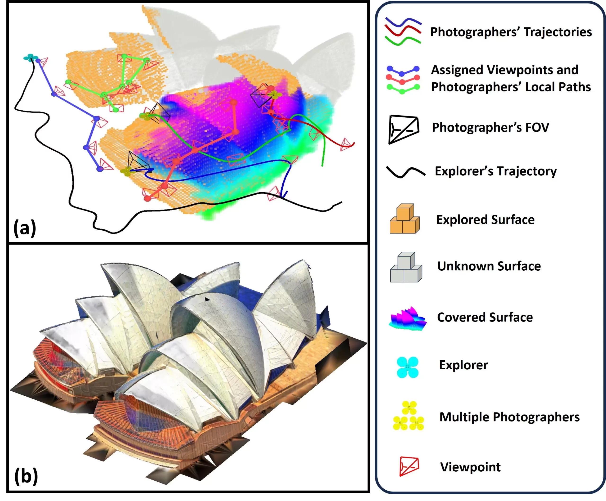
The SOAR system comprises a heterogeneous multi-UAV architecture designed to maximize data collection during environmental exploration. At its core is an “explorer” UAV equipped with LiDAR technology, which swiftly maps the terrain using a surface frontier approach. Bypassing traditional limitations, this UAV communicates compiled information to a fleet of “photographer” UAVs tasked with capturing high-resolution imagery of identified points of interest.
The technology allows the explorer to identify viewpoints dynamically, thereby facilitating extensive coverage of surfaces and optimizing routes for the photographers. The Consistent-MDMTSP method is employed to assign optimal routes to photographer UAVs, helping to balance the workload and maintain operational consistency. This innovative task allocation ensures that data collection remains efficient, minimizing idle time and enabling swift, accurate environmental analyses.
Techniques for Enhanced 3D Reconstruction
The SOAR system showcases unique capabilities in its dual reliance on both LiDAR and visual imaging. This combination not only accelerates the exploration process but also enhances the quality of the resulting 3D reconstructions. By continually adjusting to scene dynamics, SOAR maximizes coverage while minimizing the necessary number of viewpoints. This adaptability ensures optimal scanning efficiency and mitigates the risk of unnecessary detours during the data collection process.
Through rigorous simulations, the research team evaluated the efficacy of SOAR against other leading methodologies in the field. Their findings demonstrated SOAR’s superiority in generating 3D environmental reconstructions rapidly and accurately. A noteworthy contribution of this research is the development of key algorithms designed to balance real-time planning capabilities with overall efficiency—a crucial aspect for real-world applications.
Real-World Implications and Future Prospects
The ramifications of SOAR’s deployment extend across numerous fields. Potential uses include creating intricate 3D models of urban landscapes, documenting historical ruins, and providing rapid assessments in disaster response scenarios. The implications for infrastructure inspections and construction project management are equally significant, where SOAR could enable clearer mapping of sites.
Moreover, the research team has aspirations to bridge the gap between simulated environments and real-world applications. This endeavor will necessitate addressing various challenges, including localization errors and potential communication disruptions. Such improvements could drastically enhance the efficiency of UAV operations in unfamiliar or complex environments.
Looking Ahead: Enhancements and Innovations
Future research plans for the SOAR system include exploring advanced task allocation strategies to reinforce coordination among UAVs during environmental mapping. The incorporation of predictive algorithms could also allow SOAR to anticipate and adjust to environmental changes on-the-fly, further streamlining the reconstruction process. By integrating factors such as camera angles and image quality into planning, researchers hope to refine the output quality of 3D reconstructions significantly.
SOAR exemplifies the next leap in UAV technology, merging efficiency with intelligence to transform the landscape of environmental reconstruction. As researchers continue to innovate and refine these technologies, the possibilities for applications in both urban settings and natural landscapes remain boundless, marking a transformative step towards automated and high-fidelity environmental analysis.