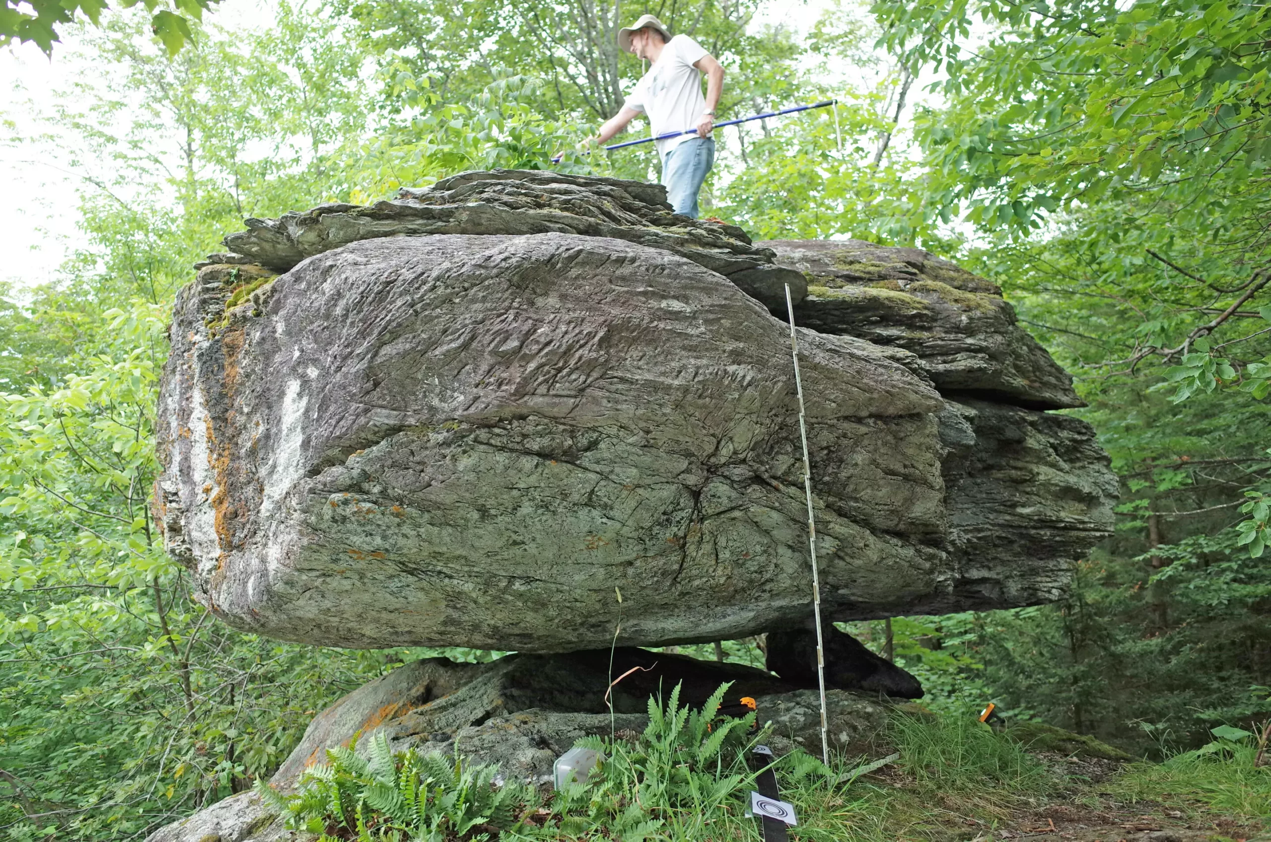
Natural disasters such as earthquakes have long fascinated both the scientific community and the public alike. In northeastern regions such as New York and Vermont, unique geological formations offer a window into understanding seismic activity. Five distinct boulders, known as precariously balanced rocks (PBRs), provide critical insights into the potential intensity of earthquakes in this area. Researchers Devin McPhillips and Thomas Pratt from the U.S. Geological Survey have undertaken a groundbreaking study to analyze how these naturally occurring structures can shed light on historical seismic events and the implications for future earthquake risks.
PBRs serve as intriguing geologic markers; they are boulders that are precariously sitting on pedestals shaped through glacial activity. Their very positioning reveals much about the forces exerted upon them, specifically the ground shaking that would be necessary to cause them to topple. By examining these boulders, seismologists can estimate the maximum shaking intensity that could be expected during an earthquake, providing a sort of geological time capsule that encapsulates seismic history.
The statistical data collected from these PBRs aligns well with existing models, specifically the 2023 National Seismic Hazard Model developed by the U.S. Geological Survey. Such alignment supports a collective understanding of earthquake risks in the region. Importantly, measurements from one particular PBR at Blue Ridge Road hinted that the risk might not be as great in its proximity, indicating a more complex relationship between local geological features and seismic activity than previously assumed.
An integral part of this research involved mapping the potential seismic hazard linked to these PBRs. By analyzing the likelihood of a boulder toppling under specific peak ground accelerations, researchers established a minimum distance from plausible earthquake sources, effectively mapping out the risks associated with potential seismic events. This innovative approach is of paramount importance not only for assessing current hazards but also for identifying active fault lines in the area.
Maps generated from this study are expected to serve as vital tools for both scientific investigation and public safety policy actions. They could guide urban planning and disaster preparedness strategies in a region that has been historically prone to seismic activity. This research contributes a valuable layer to our understanding of how unique geological features in the northeast inform larger conversations about earthquake preparedness and risk management.
The northeastern United States, particularly the areas surrounding the Adirondacks and Lake Champlain valley, demonstrates elevated seismic activity compared to other eastern U.S. regions. Historical records reveal notable seismic events, such as the magnitude 5.7 quake in Massena in 1944 and the magnitude 7.3-7.9 earthquake in nearby Quebec in 1663. Collectively, the seismicity underscores the importance of continued research in understanding the region’s hazards.
While PBR studies have mostly focused on regions with higher documented seismic risks, McPhillips indicates that the research field is beginning to evolve, thus allowing for more diverse geological contexts to be examined. By broadening the scope of study to include the northeastern U.S., this research may substantively contribute to a more comprehensive picture of earthquake risk.
Methodological Innovations and Local Engagement
The research methodology deployed to assess the fragility of PBRs utilized advanced technologies such as ground-based lidar to create precise measurements of the boulders and their pedestals. This level of detail provided significant insights into how likely each boulder was to remain stable under different seismic conditions. Local engagement played a key role in the research’s success, as knowledge from local rock enthusiasts and amateur geologists indirectly informed the researchers about locations of these fragile boulders.
In studying geological features shaped by thousands of years of glacial movements, researchers encountered the challenge of identifying PBRs in rugged, forested landscapes. Yet, insights gained from local hiking guides, publications, and internet forums provided the necessary context for their investigations, highlighting the value of community involvement in geological research.
McPhillips expresses excitement about the potential to discover additional PBRs in future explorations, hinting at the possibility of refining and improving upon their initial findings. The more locations studied, the broader the understanding of seismic hazards becomes, yielding invaluable data that contribute to enhanced preparedness for earthquake events. By utilizing PBRs as indicators, the research offers a novel framework for assessing seismic risks in areas of the northeastern United States previously under-studied.
The investigation into precariously balanced rocks serves as a reminder that even seemingly innocuous geological formations can reveal vital insights into our environmental risks. The collaboration of scientific inquiry with community knowledge enriches our understanding and engagement, forming a critical cornerstone for future research and public safety initiatives. As the field matures, ongoing efforts will likely lead to greater clarity regarding earthquake hazards, ultimately enhancing the resilience of communities in the northeastern U.S.

