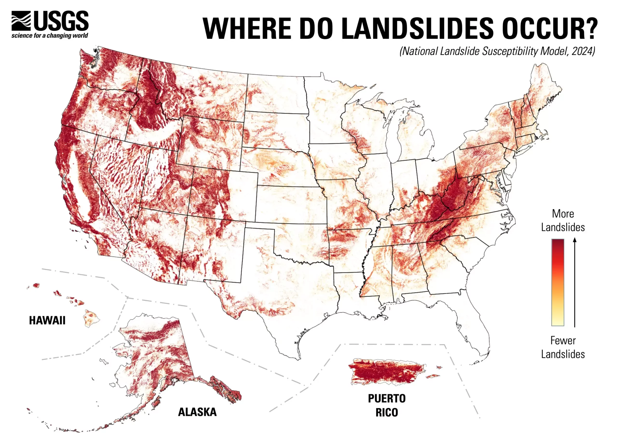
Recent developments from the U.S. Geological Survey (USGS) paint a stark picture of landslide vulnerabilities across the United States, revealing that nearly 44% of the nation is at risk of experiencing landslide phenomena. This unprecedented nationwide susceptibility map offers in-depth evaluations on a county-by-county basis, identifying where these potentially fatal geological events are likely to occur and where they pose minimal threats. The new map serves as an essential tool for urban planners and engineers, providing them with the necessary data to formulate risk-reduction strategies and improve land-use planning to mitigate the future impact of landslides.
Historically, detailed landslide assessments were primarily available for select regions recognized for their high risk. This limited geographical scope has now been broadened to include a wider range of areas that may not have previously been understood as landslide-prone. As noted by USGS researcher Ben Mirus, the effort aims to answer a crucial question: “Which areas across the entire U.S. are prone to landslides?” This comprehensive mapping project is vital for enhancing public preparedness and community responsiveness to natural hazards.
With the help of data from an inventory of nearly one million previously recorded landslides and input from high-resolution elevation data, researchers have refined our understanding of landslide dynamics. The dataset compiled by the USGS 3D Elevation Program plays a crucial role in evaluating terrain stability, which is instrumental in pinpointing the geographical areas where landslide susceptibility is heightened.
The map’s release emphasizes a proactive approach to disaster management, allowing regions at risk to take precautionary actions before landslides occur. Communities can take advantage of this information to initiate more detailed localized assessments, thus ensuring that necessary measures and protocols are established before an event transpires. This information not only aids in current disaster preparedness but also plays a crucial role in long-term urban planning and risk management.
Furthermore, the advanced computing techniques employed in the map’s formation enable a level of detail that surpasses previous continental and global maps. The ability to analyze high-resolution data equips planners with a clearer understanding of risks, which can lead to effective community strategies aimed at reducing casualties and financial damages associated with landslide occurrences.
Importantly, this map does not merely serve as a final product but acts as a dynamic tool that can evolve as further data becomes available. It highlights areas where additional mapping and research are necessary, ensuring that our understanding of landslide-related hazards remains up-to-date and relevant in the face of changing environmental conditions.
This innovative national landslide susceptibility map lays a foundation upon which strategies can be built to foster safer communities. By combining research, technology, and public awareness, the map offers a pathway to a more hazard-ready nation, where actions can be taken to mitigate the risks posed by one of nature’s most unpredictable threats.

